
File:CIAIranKarteOelGas.jpg

本预览的尺寸:584 × 599像素。 其他分辨率:234 × 240像素 | 468 × 480像素 | 687 × 705像素。
原始文件 (687 × 705像素,文件大小:51 KB,MIME类型:image/jpeg)
摘要

|
本文件已被Iran key Petroleum Sector facilities 2004.svg取代。建议您使用其他文件。请注意,删除被取代的图片需要达成一致。
|

|
| 描述 |
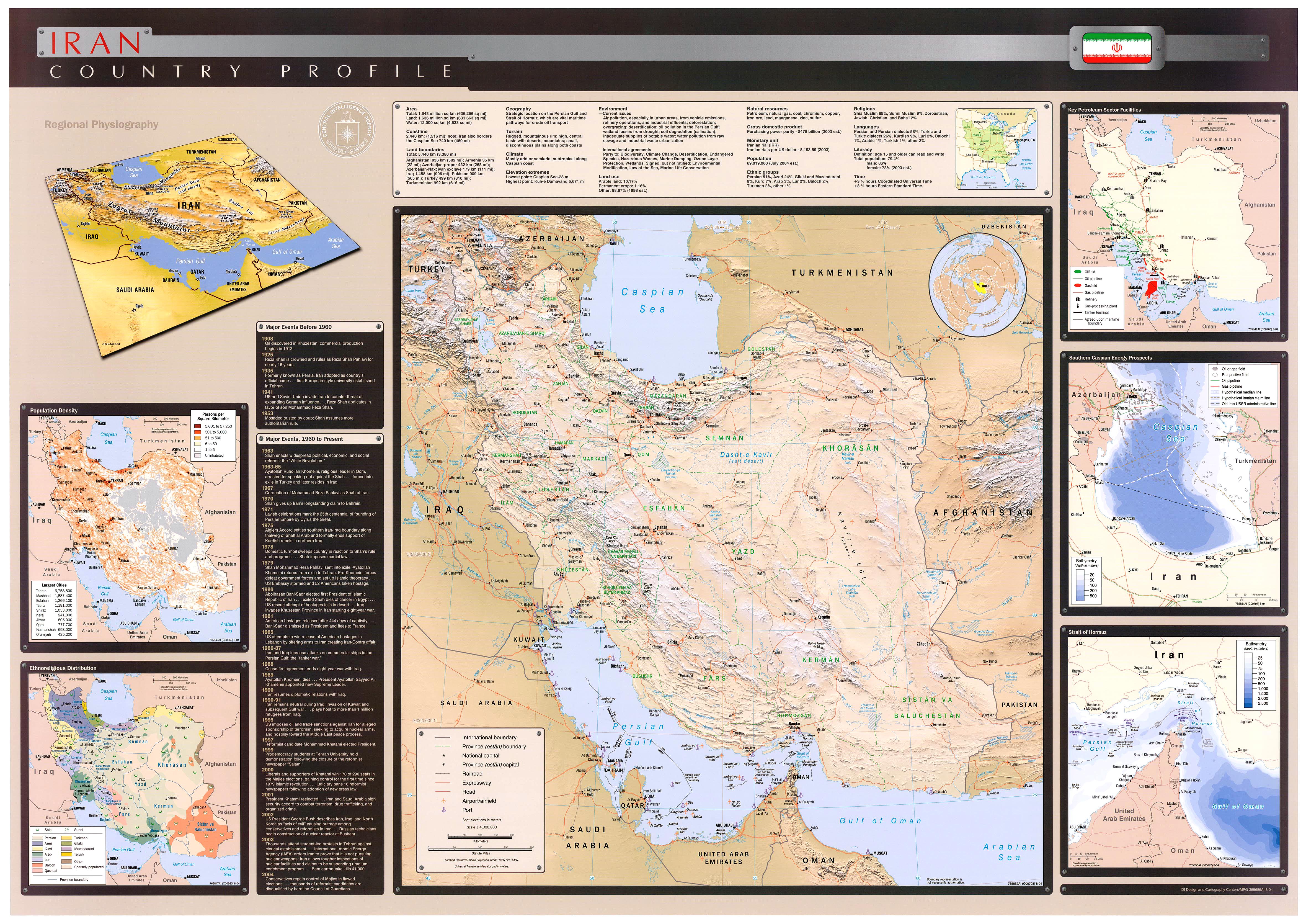
English: Key Petroleum Sector facilities (2004)
Iran (Wall Map) 2004 "Iran Country Profile" Iran map with insets: Population Density, Ethnoreligious Distribution, Key Petroleum Sector Facilities, Southern Caspian Energy Prospects and Strait Of Hormuz (2.5M) (source: CIA map) http://www.lib.utexas.edu/maps/middle_east_and_asia/iran_country_profile_2004.jpg |
| 来源 | CIA World Fact Book |
| 作者 | CIA |
许可协议
| 本图像是中央情报局雇员的职务作品。作为美国联邦政府的作品,本图像或媒体属于公有领域。
|

|
原始上传日志
原始描述頁面位於這裡。下列使用者名稱均來自en.wikipedia。
- 2008-10-20 07:34 SSZ 687×705× (52497 bytes) Key Petroleum Sector facilities (2004) Iran (Wall Map) 2004 "Iran Country Profile" Iran map with insets: Population Density, Ethnoreligious Distribution, Key Petroleum Sector Facilities, Southern Caspian Energy Prospects and Strait Of Hormuz (2.5M) (sour
文件历史
点击某个日期/时间查看对应时刻的文件。
| 日期/时间 | 缩略图 | 大小 | 用户 | 备注 | |
|---|---|---|---|---|---|
| 当前 | 2009年10月8日 (四) 04:59 | | 687 × 705(51 KB) | File Upload Bot (Magnus Manske) | {{BotMoveToCommons|en.wikipedia|year={{subst:CURRENTYEAR}}|month={{subst:CURRENTMONTHNAME}}|day={{subst:CURRENTDAY}}}} {{Information |Description={{en|Key Petroleum Sector facilities (2004) Iran (Wall Map) 2004 "Iran Country Profile" Iran map with inset |
文件用途
以下16个页面使用本文件:
全域文件用途
以下其他wiki使用此文件:
- ar.wikipedia.org上的用途
- مضيق هرمز
- برنامج إيران النووي
- منشآت نووية في إيران
- شركة النفط الإنجليزية الفارسية
- العقوبات المفروضة على إيران
- محطة بوشهر الكهروذرية
- حقل غاز الشمال
- اقتصاد إيران
- خط أنابيب تبريز-أنقرة
- خط أنابيب إيران-أرمينيا
- خط أنابيب دولة أباد-سرخس-خانكيران
- عسلوية
- الشركة الوطنية الإيرانية للنفط
- خطة ترشيد البنزين في إيران في عام 2007
- النفط في إيران
- منظمة الطاقة الذرية الإيرانية
- مفاعل أراك للماء الثقيل
- قالب:الطاقة في إيران
- منتدى الدول المصدرة للغاز
- خط أنابيب غاز إيران - باكستان
- خط أنابيب بين العراق وايران وسوريا
- الشركة الوطنية الإيرانية لتكرير وتوزيع النفط
- وزارة النفط (إيران)
- احتياطيات النفط في إيران
- احتياطيات الغاز الطبيعي في إيران
- الشركة الوطنية الإيرانية للغاز
- الشركة الوطنية الإيرانية للبتروكيماويات
- بورصة النفط الإيرانية
- تاريخ إيران الاقتصادي
- الشركة الوطنية الإيرانية لنفط الجنوب
- نفط إيران للتجارة الدولية
- شركة النفط البحرية الإيرانية
- شركة حقول النفط الإيرانية المركزية
- أزارأب للصناعات
- الطاقة في إيران
- مجموعة مابنا
- شركة الناقلات الإيرانية الوطنية
- إيران للغاز الطبيعي المسال
- الفارسية للغاز الطبيعي المسال
- وزارة الطاقة (إيران)
- azb.wikipedia.org上的用途
- cs.wikipedia.org上的用途
- el.wikipedia.org上的用途
- en.wikipedia.org上的用途
查看本文件的更多全域用途。