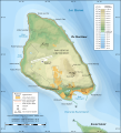
File:Mackinac Island topographic map-en.svg

此SVG文件的PNG预览的大小:545 × 600像素。 其他分辨率:218 × 240像素 | 436 × 480像素 | 698 × 768像素 | 931 × 1,024像素 | 1,862 × 2,048像素 | 1,200 × 1,320像素。
原始文件 (SVG文件,尺寸为1,200 × 1,320像素,文件大小:457 KB)
文件历史
点击某个日期/时间查看对应时刻的文件。
| 日期/时间 | 缩略图 | 大小 | 用户 | 备注 | |
|---|---|---|---|---|---|
| 当前 | 2010年7月7日 (三) 17:43 |  | 1,200 × 1,320(457 KB) | Liandrei | fix |
| 2010年7月7日 (三) 17:39 |  | 1,196 × 1,316(133 KB) | Liandrei | fix | |
| 2010年7月7日 (三) 17:35 |  | 1,196 × 1,316(133 KB) | Liandrei | Removed border | |
| 2009年6月9日 (二) 01:37 |  | 1,200 × 1,320(462 KB) | Sting | == Summary == {{Location|45|51|53|N|84|37|30|W|scale:30000}} {{Information| |Description={{en|Topographic map in English of Mackinac Island, Lake Huron, Michigan, USA.<br/>''Note: The shaded relief is a raster image embedded in th |
文件用途
以下页面使用本文件:
全域文件用途
以下其他wiki使用此文件:
- ca.wikipedia.org上的用途
- de.wikipedia.org上的用途
- en.wikipedia.org上的用途
- Mackinac Island
- Fort Mackinac
- Fort Holmes
- Mackinac Island State Park
- Andrew Holmes (army officer)
- Battle of Mackinac Island (1814)
- Mission House (Mackinac Island)
- Arch Rock (Mackinac Island)
- Round Island Light, Michigan
- Marquette Park (Mackinac Island)
- Round Island Passage Light
- Wikipedia:Graphics Lab/Photography workshop/Archive/Jul 2010
- File talk:Mackinac Island topographic map-en.svg
- Portal:Islands/Selected article
- Portal:Islands/Selected article/55
- en.wikivoyage.org上的用途
- es.wikipedia.org上的用途
- fr.wikipedia.org上的用途
- ja.wikipedia.org上的用途
- kk.wikipedia.org上的用途
- lt.wikipedia.org上的用途
- nl.wikipedia.org上的用途
- pl.wikipedia.org上的用途
- ru.wikipedia.org上的用途
- www.wikidata.org上的用途
- xmf.wikipedia.org上的用途


