
File:Arthur 2002 rainfall.png

預覽大小:633 × 600 像素。 其他解析度:253 × 240 像素 | 507 × 480 像素 | 839 × 795 像素。
原始檔案 (839 × 795 像素,檔案大小:21 KB,MIME 類型:image/png)
摘要
| 描述 |
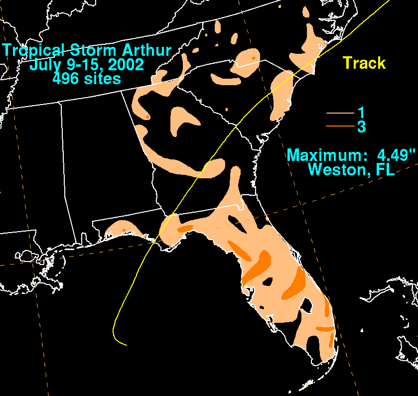
English: Storm total rainfall map of Tropical Storm Arthur during July 2002. |
|||
| 日期 | ||||
| 來源 | WPC tropical cyclone rainfall data | |||
| 作者 | David Roth, Weather Prediction Center, Camp Springs, Maryland | |||
| 授權許可 (重用此檔案) |
|
原始上傳日誌
| 日期/時間 | 尺寸 | 使用者 | 備註 |
|---|---|---|---|
| 2008年1月8日, 05:08:36 | 839 × 795 (23653 bytes) | Hurricanehink (留言 · 貢獻) | == Summary == {{Information |Description=This shows the total rainfall from Tropical Storm Arthur (2002) in the United States. |Source=Hydrometeorological Prediction Center report on Tropical Storm Elena. [http://www.hpc.ncep.noaa.gov/tropical/rain/arthur |
檔案歷史
點選日期/時間以檢視該時間的檔案版本。
| 日期/時間 | 縮圖 | 尺寸 | 使用者 | 備註 | |
|---|---|---|---|---|---|
| 目前 | 2014年8月18日 (一) 12:05 | | 839 × 795(21 KB) | GifTagger | Bot: Converting file to superior PNG file. (Source: Arthur_2002_rainfall.gif). This GIF was problematic due to non-greyscale color table. |
檔案用途
下列2個頁面有用到此檔案:
全域檔案使用狀況
以下其他 wiki 使用了這個檔案:
- de.wikipedia.org 的使用狀況
- en.wikipedia.org 的使用狀況