
File:Gulf of Thailand.svg

此 SVG 檔案的 PNG 預覽的大小:488 × 479 像素。 其他解析度:245 × 240 像素 | 489 × 480 像素 | 782 × 768 像素 | 1,043 × 1,024 像素 | 2,086 × 2,048 像素。
原始檔案 (SVG 檔案,表面大小:488 × 479 像素,檔案大小:387 KB)
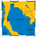
Mercator projection of Gulf of Thailand.
Public Domain map created by Online Map Creation:
http://www.aquarius.geomar.de/omc/omc_intro.html archive copy at the Wayback Machine
Modified by me (User:Feydey).
Other versions
-
 Italiano
 -
 Македонски
 -
 বাংলা
বাংলা


| 此作品已由其作者,User:Feydey,釋出至公有領域。此授權條款在全世界均適用。 這可能在某些國家不合法,如果是的話: User:Feydey授予任何人有權利使用此作品於任何用途,除受法律約束外,不受任何限制。
|
derivative works
Derivative works of this file:
檔案歷史
點選日期/時間以檢視該時間的檔案版本。
| 日期/時間 | 縮圖 | 尺寸 | 用戶 | 備註 | |
|---|---|---|---|---|---|
| 目前 | 2020年1月16日 (四) 11:06 | | 488 × 479(387 KB) | Paul 012 | The label "Andaman Sea" was in the area officially defined as the Strait of Malacca. |
| 2007年6月27日 (三) 17:53 |  | 488 × 479(387 KB) | Feydey | Mercator projection of Gulf of Thailand. Public Domain map created by Online Map Creation: http://www.aquarius.geomar.de/omc/omc_intro.html Modified by me (User:Feydey). {{PD}} Category:Maps of seas |
檔案用途
下列頁面有用到此檔案:
全域檔案使用狀況
以下其他 wiki 使用了這個檔案:
- af.wikipedia.org 的使用狀況
- azb.wikipedia.org 的使用狀況
- br.wikipedia.org 的使用狀況
- ca.wikipedia.org 的使用狀況
- ckb.wikipedia.org 的使用狀況
- da.wikipedia.org 的使用狀況
- de.wikinews.org 的使用狀況
- el.wikipedia.org 的使用狀況
- en.wikipedia.org 的使用狀況
- fa.wikipedia.org 的使用狀況
- fi.wikipedia.org 的使用狀況
- fr.wikipedia.org 的使用狀況
- hi.wikipedia.org 的使用狀況
- hu.wikipedia.org 的使用狀況
- ilo.wikipedia.org 的使用狀況
- io.wikipedia.org 的使用狀況
- ja.wikipedia.org 的使用狀況
- ka.wikipedia.org 的使用狀況
- km.wikipedia.org 的使用狀況
- ko.wikipedia.org 的使用狀況
- la.wikipedia.org 的使用狀況
- lo.wikipedia.org 的使用狀況
- min.wikipedia.org 的使用狀況
- ml.wikipedia.org 的使用狀況
- mr.wikipedia.org 的使用狀況
- ms.wikipedia.org 的使用狀況
- mt.wikipedia.org 的使用狀況
- my.wikipedia.org 的使用狀況
- nn.wikipedia.org 的使用狀況
- pa.wikipedia.org 的使用狀況
- pnb.wikipedia.org 的使用狀況
- simple.wikipedia.org 的使用狀況
- sr.wikipedia.org 的使用狀況
- sv.wikipedia.org 的使用狀況
- sw.wikipedia.org 的使用狀況
- ta.wikipedia.org 的使用狀況
- th.wikipedia.org 的使用狀況
- tl.wikipedia.org 的使用狀況
- tr.wikipedia.org 的使用狀況
- uk.wikipedia.org 的使用狀況
- ur.wikipedia.org 的使用狀況
- vi.wikipedia.org 的使用狀況
- war.wikipedia.org 的使用狀況
檢視此檔案的更多全域使用狀況。