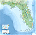
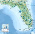
File:Florida topographic map-en.svg

此SVG文件的PNG预览的大小:617 × 600像素。 其他分辨率:247 × 240像素 | 494 × 480像素 | 790 × 768像素 | 1,053 × 1,024像素 | 2,106 × 2,048像素 | 2,890 × 2,810像素。
原始文件 (SVG文件,尺寸为2,890 × 2,810像素,文件大小:2.51 MB)
文件历史
点击某个日期/时间查看对应时刻的文件。
| 日期/时间 | 缩略图 | 大小 | 用户 | 备注 | |
|---|---|---|---|---|---|
| 当前 | 2008年12月16日 (二) 15:26 |  | 2,890 × 2,810(2.51 MB) | Sting | Added summits names |
| 2008年12月15日 (一) 01:34 |  | 2,890 × 2,810(2.51 MB) | Sting | == Summary == {{Information |Description={{en|Topographic map of the State of Florida, USA (2000 Census).<br/>''Note: the background map is a raster image embedded in the SVG file.''} |
文件用途
全域文件用途
以下其他wiki使用此文件:
- af.wikipedia.org上的用途
- ang.wikipedia.org上的用途
- arz.wikipedia.org上的用途
- az.wikipedia.org上的用途
- ban.wikipedia.org上的用途
- be.wikipedia.org上的用途
- bn.wikipedia.org上的用途
- ca.wikipedia.org上的用途
- de.wikipedia.org上的用途
- el.wikipedia.org上的用途
- en.wikipedia.org上的用途
- Portal:Geography
- Portal:Geography/Featured picture
- Wikipedia:WikiProject Florida
- Portal:Florida
- User talk:Sting
- Wikipedia:Graphics Lab/Resources/Tutorials
- Wikipedia:Featured pictures/Diagrams, drawings, and maps/Maps
- Geography of Florida
- Florida
- Wikipedia:WikiProject United States/Recognized content
- Wikipedia:Featured pictures thumbs/26
- Wikipedia:WikiProject United States/Quality content
- User talk:Jujutacular/Archive 9
- Wikipedia:Featured picture candidates/December-2010
- Wikipedia:Featured picture candidates/Topographic map of Florida
- Talk:Geography of Florida
- Wikipedia:WikiProject Florida/Recognized content
- Template:POTD/2013-03-03
- Portal:Geography/Featured picture/4
- Wikipedia:Picture of the day/March 2013
- User talk:Jujutacular/Archive 15
- Wikipedia:Main Page history/2013 March 3
- User:Abyssal/bla
- Portal:Geography/Selected picture
- Wikipedia:WikiProject United States/Featured pictures
- es.wikipedia.org上的用途
- fr.wikipedia.org上的用途
- fy.wikipedia.org上的用途
- ga.wikipedia.org上的用途
- gl.wikipedia.org上的用途
- gn.wikipedia.org上的用途
- hu.wikipedia.org上的用途
- hy.wikipedia.org上的用途
查看此文件的更多全域用途。


